How Studlagil Canyon formed and why it stayed hidden
The columns at Stuðlagil are old, but the view of them is new. Whether you write it Stuðlagil or plain Studlagil, the canyon sat under a high, muddy river until a dam upstream took much of the water away. This guide follows the story from cooling lava to the dam, and to the photograph that made the place famous.
Lava that cracked as it cooled
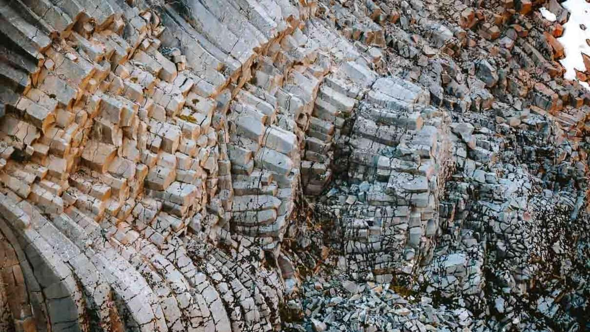
The walls of the canyon are basalt, laid down as thick lava flows. Lava that pools deep cools slowly, and as it cools it shrinks. The shrinking pulls the rock apart along cracks that meet at fairly regular angles, and through a thick flow those cracks join up into long columns, many of them six-sided when seen from above. Geologists call this columnar jointing, and Iceland, built largely from lava, shows it in many places, from Svartifoss in the south to the roadside cliff of Gerðuberg (how Stuðlagil compares with them). At Stuðlagil the listings put the tallest columns at up to about 100 feet (30 m).
Why some columns stand straight and others fan
The cracks grow inward from whichever surface is losing heat, so the columns end up at right angles to it. Where a flow cooled evenly from the top and the base, they stand upright like organ pipes. Where the lava lost heat from the sides as well, they curve and splay into fans. Both kinds show along the gorge, sometimes in the same stretch of wall, and on the east-side walk the small Stuðlafoss waterfall drops through a frame of them before you reach the canyon floor.
A muddy river on top
For most of its history the gorge carried the full force of the Jökulsá á Dal, known locally as Jökla. Fed by meltwater from Vatnajökull, it was the longest river in East Iceland, about 93 miles (150 km) from the ice to the sea before the dams. It ran high and brown through Jökuldalur, carrying by one estimate about 120 tonnes of sediment an hour toward the coast. In water like that the lower walls of the canyon stayed submerged, and whatever rose above the waterline drew little attention.
The dam that lowered the water
The change came from upstream. Iceland's biggest power station, the Kárahnjúkar Hydropower Plant, was finished in 2009 to feed an aluminum smelter. Its dams on Jökla hold back the Hálslón reservoir, and much of the water is diverted east into Lagarfljót instead of running down its old valley. Below the dams the river now carries roughly 95 cubic meters a second through the canyon, down from some 205.
With less than half the water, the river dropped and cleared. Between about 2006 and 2009 the columns came into view along both banks, right down to the waterline.
Named and made famous in 2016
Even then, almost nobody outside the valley knew. That changed in 2016, when an Icelandic photographer and travel writer photographed the gorge, gave it the name Stuðlagil (from stuðlar, basalt columns, and gil, a gorge) and wrote the first article about it. The story spread after an airline's in-flight magazine featured it, and the visitors followed. The farmers who own the land now run the car parks and paths, on the west bank at Grund and on the east bank near Klaustursel. Landowners charge for parking on both sides, so check the fee on arrival.
Why the river changes color
The dam also explains the water. Most of the year the canyon gets the smaller, clearer flow, which runs blue-green. In late summer, usually from about August, Hálslón fills and spills over, and silty gray-brown glacial water pours down the old channel again, raising the river into autumn in most years. Tanni Travel and Marina Travel both say the color ranges from turquoise to gray with the season and conditions, so nobody can promise you the blue. When the river runs turquoise turns that into a calendar.
A discovery with a cost
Not everyone celebrates the story. Hálslón flooded a stretch of highland wilderness, along with waterfalls such as Töfrafoss, and the project was fiercely debated in Iceland. So the canyon is sometimes called an accidental discovery, one landscape lost in the highlands and another uncovered downstream. Visitors who come for the columns are, in a sense, looking at a side effect of a smelter's power supply. Knowing that does not spoil the view, though it makes the canyon a stranger sight than the photos suggest.
Seeing the rock up close
The geology reads best from the bottom. On the east bank, a track running about 1.5 miles (2.5 km) in each direction leads past Stuðlafoss down to the canyon floor, where the columns rise above you. Only Tanni Travel's canyon hike with the Vök Baths, from ~$407, and its small-group hike, from ~$328, schedule that walk. From the west bank at Grund, stairs lead to platforms that look down on the columns, and Saga Travel, from ~$231, spends its canyon time there. Tanni's Stuðlagil Canyon Express, which adds the Vök Baths for ~$324, also uses the west-side platforms, and that is its catch, since it never walks down to the river and has only a few reviews so far.
Two hours with the columns, your party only
Marina Travel's private tour leaves the port at about 8:30 am for roughly 5 hours, with roughly 2 hours at Stuðlagil to walk marked paths between viewpoints, and a local driver-guide. The price, from ~$1,176, covers the whole group, and cancellation is free up to 24 hours ahead.
Marina Travel's private car allows about two hours among the columns for ~$1,176 split across your party; its listing names no bank, so ask before you book. BusTravel's excursion, from ~$224, allows about an hour without naming a side. Columns also frame Litlanesfoss below Hengifoss, covered in the waterfalls on the way to Studlagil. For the platforms against the riverbank, read The canyon hike, east side or west side. For the walk itself, see what to wear and bring for the canyon, and for the rest of the region, other East Iceland day trips.